Tocht Te voet Proença a Nova e Peral - A História na Paisagem - Photo

Tous les sentiers balisés d’Europe PRO

© OpenStreetMap contributors
Lengte
Lengte
5 km
Max. hoogte
Max. hoogte
417 m
Positief hoogteverschil
69 m
Km-Effort
Km-Effort  
5,9 km
Min. hoogte
Min. hoogte
370 m
Negatief hoogteverschil
89 m
Boucle
Boucle
Neen
Markering
Markering
Datum van aanmaak :
2022-02-14 15:07:55.36
Laatste wijziging :
2022-02-14 15:07:55.36

(0 Bericht)

Te voet
Te voet
1h21
Moeilijkheid : Gemakkelijk

Scan deze QR-code om de tocht te openen in de SityTrail-applicatie

Gratisgps-wandelapplicatie

Logo SityTrail SityTrail

IGN / Geografische instituten

SityTrail uit de App Store downloaden SityTrail uit Google Play downloaden

Logo SityTrail SityTrail World

De wereld gaat voor u open

SityTrail uit de App Store downloaden SityTrail uit Google Play downloaden SityTrail op Huawei AppGallery downloaden

Over ons

Tocht Te voet van 5 km beschikbaar op Centro, Castelo Branco, Proença a Nova e Peral. Deze tocht wordt voorgesteld door SityTrail - itinéraires balisés pédestres.

Beschrijving

Trail created by Município de Proença-a-Nova.

Symbol: Yellow over Red


Website: https://www.cm-proencanova.pt/Lazer/ContentShow.aspx?ContentId=121

Foto's

Plaatsbepaling

Land:
Portugal
Regio :
Centro
Departement/Provincie :
Castelo Branco
Gemeente :
Proença a Nova e Peral
Locatie:
Proença-a-Nova
Vertrek:(UTM)
597667 ; 4398487 (29S) N.

Wandeltochten in de omgeving

Tocht Te voet  - Caminho do Xisto de Ermida e Figueiredo - Photo
Te voet
PRO

Te voet

Gemakkelijk
, Centro, Castelo Branco, Portugal
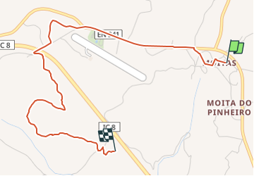
6,7 km | 9,2 km-effort
2h 5min
Neen


Sluiten
Mijn abonnementen